
Districts of Azad Jummu Kashmir
.Muzaffarabad |
.Neelum |
.Sudhnutti |
.Bhimber |
.Poonch |
.Mirpur |
.Bagh |
.Kotli |
.Haveli |
.Hattian |


جب نیند سے آنکھیں بوجھل ہوں
اور اپنے آنکھ سے اوجھل ہوں
پھر نیند بھلا کب آتی ہے
جب دل میں بسنے والے بھی
اور ساتھ میں ہنسنے والے بھی
دور کہیں وہ بستے ہوں
کسی اور کے ساتھ وہ ہنستے ہوں
پھر نیند بھلا کب آتی ہے
جب غم کی رات اندھیری ہو
اور اس میں یاد بھی تیری ہو
... نہ دل میں کوئی اجالا ہو
پھر نیند بھلا کب آتی ہے
پھر نیند بھلا کب آتی ہے۔۔۔
ZAKIR SIDDIQUI
=====================================================================
 Chikar
The hill station of Chikar, 27 miles from Muzaffarabad has grown into a fairly large township. Three miles from Chikar is the hill station known as Loonbagla which is situated in the middle of a vast range of densely grown forests. The outstanding features of this hill station are its healthy climate and picturesque surroundings. Chikar is linked with Muzaffarabad by a motor able road and is connected with Bagh in Poonch district via Sudhan Gali.

Neela Butt
From Dhirkot 6 kilometers ahead, this spot is situated at an altitude of 2000 meters from sea level. It is worth seeing from the tourist point of view as well as its historical background. On 23rd August 1947 the Mujahideen-e-Azadi got united at this place, aiming to get independence from India. Considering its tourist importance the Azad Jammu Kashmir Government has constructed more than half dozen huts for the visitors.

Dhirkote
This fascinating and charming place of Distric Bagh is 24 kilometeres from Kohala, the gateway of Azad Kashmir, and 132 kilometers from Islamabad, the Capital of Pakistan. Located at an altitude of 1676 meters, Dhirkote possesses an extremely pleasant and healthy climate. The places is very popular among the people as a tourist resort mainly due to easy accass, suitable altitude and beautiful landscape.
In the heart of the calm and quiet Deodar and Kail mixed forest, there is a posh Forest Rest House, three tourist huts and one log hut which are greatly sought after by tourists in summer.
Dhirkot is linked with Kohala by a black-top road. Direct transport services are available from Rawalpindi(Pak) and Muazaffarabad(AJK). There is a bazaar on top of the hill which provides essential commodities. Education, medical, banking, telephone, telegraph and Internet facilities are also available here.
Dhirkot is best approached from Rawalpindi via Murree and the nearby Kohala Bridge over the Jhelum, the gateway to Azad Kashmir. It is small township situated at 6,000 feet above sea level and has a bracing climate. It is famous for its healthy surroundings, high altitude landscape. The town also is famous for the beauty spots. Almost all the area is covered with green trees like deodar, pine and oak. the Dak Bungalow - rest house - which is situated amidst the dense forest is 5,500 feet above the sea level. the Dhirkot is also famous for the fruits mainly apples and apricots.


.jpg)
.jpg)
.jpg)
.jpg)
.jpg)
.jpg)
.jpg)
.jpg)
.jpg)
.jpg)
.jpg)
.jpg)
.jpg)
.jpg)
.jpg)


اور اپنے آنکھ سے اوجھل ہوں
پھر نیند بھلا کب آتی ہے
جب دل میں بسنے والے بھی
اور ساتھ میں ہنسنے والے بھی
دور کہیں وہ بستے ہوں
کسی اور کے ساتھ وہ ہنستے ہوں
پھر نیند بھلا کب آتی ہے
جب غم کی رات اندھیری ہو
اور اس میں یاد بھی تیری ہو
... نہ دل میں کوئی اجالا ہو
پھر نیند بھلا کب آتی ہے
پھر نیند بھلا کب آتی ہے۔۔۔
ZAKIR SIDDIQUI
=====================================================================
The beauty of villages in azad kashmir
 Chikar
The hill station of Chikar, 27 miles from Muzaffarabad has grown into a fairly large township. Three miles from Chikar is the hill station known as Loonbagla which is situated in the middle of a vast range of densely grown forests. The outstanding features of this hill station are its healthy climate and picturesque surroundings. Chikar is linked with Muzaffarabad by a motor able road and is connected with Bagh in Poonch district via Sudhan Gali.

Neela Butt
From Dhirkot 6 kilometers ahead, this spot is situated at an altitude of 2000 meters from sea level. It is worth seeing from the tourist point of view as well as its historical background. On 23rd August 1947 the Mujahideen-e-Azadi got united at this place, aiming to get independence from India. Considering its tourist importance the Azad Jammu Kashmir Government has constructed more than half dozen huts for the visitors.

Dhirkote
This fascinating and charming place of Distric Bagh is 24 kilometeres from Kohala, the gateway of Azad Kashmir, and 132 kilometers from Islamabad, the Capital of Pakistan. Located at an altitude of 1676 meters, Dhirkote possesses an extremely pleasant and healthy climate. The places is very popular among the people as a tourist resort mainly due to easy accass, suitable altitude and beautiful landscape.
In the heart of the calm and quiet Deodar and Kail mixed forest, there is a posh Forest Rest House, three tourist huts and one log hut which are greatly sought after by tourists in summer.
Dhirkot is linked with Kohala by a black-top road. Direct transport services are available from Rawalpindi(Pak) and Muazaffarabad(AJK). There is a bazaar on top of the hill which provides essential commodities. Education, medical, banking, telephone, telegraph and Internet facilities are also available here.
Dhirkot is best approached from Rawalpindi via Murree and the nearby Kohala Bridge over the Jhelum, the gateway to Azad Kashmir. It is small township situated at 6,000 feet above sea level and has a bracing climate. It is famous for its healthy surroundings, high altitude landscape. The town also is famous for the beauty spots. Almost all the area is covered with green trees like deodar, pine and oak. the Dak Bungalow - rest house - which is situated amidst the dense forest is 5,500 feet above the sea level. the Dhirkot is also famous for the fruits mainly apples and apricots.
Muzaffarabad
Situated at the confluence of the Jhelum and the Neelum rivers Muzaffarabad the capital of the State of Azad Jammu and Kashmir is at a distance of 86 miles from Rawalpindi a nd
49 miles from Abbottabad. Surrounded by mountains, it looks like a
walled town. It is the administrative capital of Azad Kashmir. Behind
the Secretariat to the east is a road climbing above the town from where
one can walk up to Pir Chinasi at 2,900 meters with good views of the
Jhelum Valley and the higher mountains above the Neelum to the north.
From the cool on the Abbottabad Road, you can walk along the ridge
looking over the Jhelum and Kunhar rivers. Past the Red fort, crossing
Neelum river at Ghori, a few km way is 'Makra mountain' 3,890 meters
which is visible from Muzaffarabad and continues on to Shogran in the
Kaghan Valley. This is a superb short trek, although you need to camp
overnight halfway. The upper Jhelum valley makes another interesting
scenic excursion from Muzaffarabad. follow the Jhelum upstream, taking
the road beneath the Domel bridge. This was the old route to Srinagar.
The valley is broad with raised terraces above the river. Rice and maize
are widely grown. Some 10 kms out of Muzaffarabad the river widens to
from a small lake. This was created by a landslip some years ago. There
is a small Angler's Hut here, which makes a pleasant picnic spot. It is
possible to take boats out on the river. Book through the Tourist
Department in Muzaffarabad. The city was founded by Sultan Muzaffar Khan
of Bamba dynasty and was the seat of an independent State for quite a
long period under his successors. The city is now a combination of old
and new buildings and a blend of different cultures and languages. It
has besides official buildings, farms, parks and the historic forts
standing on the banks of the Neelum, Muzaffarabad, Mirpur, Rawlakot and
Kotli are connected with Pakistan by the Micro-weave system of
telephone. There are rest houses, good hotels and guest houses in
Muzaffarabad city where the tourists can stay. The rather sleazy bazaar
in Muzaffarabad can be explored for its walnut carvings and its Kashmiri
shawls. It is sometimes possible to get a good bargain.
nd
49 miles from Abbottabad. Surrounded by mountains, it looks like a
walled town. It is the administrative capital of Azad Kashmir. Behind
the Secretariat to the east is a road climbing above the town from where
one can walk up to Pir Chinasi at 2,900 meters with good views of the
Jhelum Valley and the higher mountains above the Neelum to the north.
From the cool on the Abbottabad Road, you can walk along the ridge
looking over the Jhelum and Kunhar rivers. Past the Red fort, crossing
Neelum river at Ghori, a few km way is 'Makra mountain' 3,890 meters
which is visible from Muzaffarabad and continues on to Shogran in the
Kaghan Valley. This is a superb short trek, although you need to camp
overnight halfway. The upper Jhelum valley makes another interesting
scenic excursion from Muzaffarabad. follow the Jhelum upstream, taking
the road beneath the Domel bridge. This was the old route to Srinagar.
The valley is broad with raised terraces above the river. Rice and maize
are widely grown. Some 10 kms out of Muzaffarabad the river widens to
from a small lake. This was created by a landslip some years ago. There
is a small Angler's Hut here, which makes a pleasant picnic spot. It is
possible to take boats out on the river. Book through the Tourist
Department in Muzaffarabad. The city was founded by Sultan Muzaffar Khan
of Bamba dynasty and was the seat of an independent State for quite a
long period under his successors. The city is now a combination of old
and new buildings and a blend of different cultures and languages. It
has besides official buildings, farms, parks and the historic forts
standing on the banks of the Neelum, Muzaffarabad, Mirpur, Rawlakot and
Kotli are connected with Pakistan by the Micro-weave system of
telephone. There are rest houses, good hotels and guest houses in
Muzaffarabad city where the tourists can stay. The rather sleazy bazaar
in Muzaffarabad can be explored for its walnut carvings and its Kashmiri
shawls. It is sometimes possible to get a good bargain.
Muzaffarabad Fort
Border skirmishes between the armies of renowned Mughal Akbar and the Chak rulers of Kashmir were common. To ensure safety of the people, and the land, the Chaks realized to raise defense posts and efficiently counter the offensives. During the year 1949 the construction of the red fort was undertaken. It was finally completed by Sultan Muzaffar Khan the founder of Muzaffarabad city during 1646. When the Mughals overtook the Kashmir rule, this fort lost its importance. The Mughals were more interested in Kabul, Bokhara and Badakshan. During the Durrani rule the fort again came into limelight and its importance was rediscovered. Maharaja Gulab Sign and Ranbir Singh, the Dogra rulers, reconstructed and extended the fort for political and military operations. Towards the end of 1947 the Dogra forces filed awa y
leaving the fort wide open to anybody. The architectonics of the fort
show that great experts in design and structure participated in its
construction. It is surrounded on three sides by Neelum river formally
known as Kishan Ganga. the northern part had terraces with steps leading
to the bank of the river. The Eastern side of the fort was very well
protected from the hazards of flood waters but some parts in the north
were slightly damaged. There was an inn at the entry of the fort which
has to traces left now. It has been in the bad shape for quite some time
and wears deserted look. The structure still stands with all its
inherent glory, grandeur and its historical background.
y
leaving the fort wide open to anybody. The architectonics of the fort
show that great experts in design and structure participated in its
construction. It is surrounded on three sides by Neelum river formally
known as Kishan Ganga. the northern part had terraces with steps leading
to the bank of the river. The Eastern side of the fort was very well
protected from the hazards of flood waters but some parts in the north
were slightly damaged. There was an inn at the entry of the fort which
has to traces left now. It has been in the bad shape for quite some time
and wears deserted look. The structure still stands with all its
inherent glory, grandeur and its historical background.
 Bagh
Bagh
Bagh, the Tehsil Headquarters of Distt. Poonch, is situate at the confluence of two mini rivers - Malwani and Mall which flow all the year round. Bagh city comprises at least 5,000 shops and has a hospital. the total population of the Tehsil Headquarters is over 3 lacs. Two rest houses are available for tourists. Permission for stay can be obtained from the nearby Forest Department, P.W.D. There are two degree colleges, one is for boys and the other for girls. 'Haji Pir Pass' is 20 miles from Bagh city which is linked with metalled road.
Banjosa
 Banjosa
is Situated 20 kilometers from Rawalakot, at an altitude of 1981
meters. Its scenic beauty and impressive surrounding is compelling and
attracts tourists to reach here to enjoy the nature for a possible
comeback. Amidst the captivating beauty of Banjosa the artificial lake
reflects the dense forest standing along the surrounding of the resting
calm waters of Banjosa lake.
Banjosa
is Situated 20 kilometers from Rawalakot, at an altitude of 1981
meters. Its scenic beauty and impressive surrounding is compelling and
attracts tourists to reach here to enjoy the nature for a possible
comeback. Amidst the captivating beauty of Banjosa the artificial lake
reflects the dense forest standing along the surrounding of the resting
calm waters of Banjosa lake.
Situated at the confluence of the Jhelum and the Neelum rivers Muzaffarabad the capital of the State of Azad Jammu and Kashmir is at a distance of 86 miles from Rawalpindi a
 nd
49 miles from Abbottabad. Surrounded by mountains, it looks like a
walled town. It is the administrative capital of Azad Kashmir. Behind
the Secretariat to the east is a road climbing above the town from where
one can walk up to Pir Chinasi at 2,900 meters with good views of the
Jhelum Valley and the higher mountains above the Neelum to the north.
From the cool on the Abbottabad Road, you can walk along the ridge
looking over the Jhelum and Kunhar rivers. Past the Red fort, crossing
Neelum river at Ghori, a few km way is 'Makra mountain' 3,890 meters
which is visible from Muzaffarabad and continues on to Shogran in the
Kaghan Valley. This is a superb short trek, although you need to camp
overnight halfway. The upper Jhelum valley makes another interesting
scenic excursion from Muzaffarabad. follow the Jhelum upstream, taking
the road beneath the Domel bridge. This was the old route to Srinagar.
The valley is broad with raised terraces above the river. Rice and maize
are widely grown. Some 10 kms out of Muzaffarabad the river widens to
from a small lake. This was created by a landslip some years ago. There
is a small Angler's Hut here, which makes a pleasant picnic spot. It is
possible to take boats out on the river. Book through the Tourist
Department in Muzaffarabad. The city was founded by Sultan Muzaffar Khan
of Bamba dynasty and was the seat of an independent State for quite a
long period under his successors. The city is now a combination of old
and new buildings and a blend of different cultures and languages. It
has besides official buildings, farms, parks and the historic forts
standing on the banks of the Neelum, Muzaffarabad, Mirpur, Rawlakot and
Kotli are connected with Pakistan by the Micro-weave system of
telephone. There are rest houses, good hotels and guest houses in
Muzaffarabad city where the tourists can stay. The rather sleazy bazaar
in Muzaffarabad can be explored for its walnut carvings and its Kashmiri
shawls. It is sometimes possible to get a good bargain.
nd
49 miles from Abbottabad. Surrounded by mountains, it looks like a
walled town. It is the administrative capital of Azad Kashmir. Behind
the Secretariat to the east is a road climbing above the town from where
one can walk up to Pir Chinasi at 2,900 meters with good views of the
Jhelum Valley and the higher mountains above the Neelum to the north.
From the cool on the Abbottabad Road, you can walk along the ridge
looking over the Jhelum and Kunhar rivers. Past the Red fort, crossing
Neelum river at Ghori, a few km way is 'Makra mountain' 3,890 meters
which is visible from Muzaffarabad and continues on to Shogran in the
Kaghan Valley. This is a superb short trek, although you need to camp
overnight halfway. The upper Jhelum valley makes another interesting
scenic excursion from Muzaffarabad. follow the Jhelum upstream, taking
the road beneath the Domel bridge. This was the old route to Srinagar.
The valley is broad with raised terraces above the river. Rice and maize
are widely grown. Some 10 kms out of Muzaffarabad the river widens to
from a small lake. This was created by a landslip some years ago. There
is a small Angler's Hut here, which makes a pleasant picnic spot. It is
possible to take boats out on the river. Book through the Tourist
Department in Muzaffarabad. The city was founded by Sultan Muzaffar Khan
of Bamba dynasty and was the seat of an independent State for quite a
long period under his successors. The city is now a combination of old
and new buildings and a blend of different cultures and languages. It
has besides official buildings, farms, parks and the historic forts
standing on the banks of the Neelum, Muzaffarabad, Mirpur, Rawlakot and
Kotli are connected with Pakistan by the Micro-weave system of
telephone. There are rest houses, good hotels and guest houses in
Muzaffarabad city where the tourists can stay. The rather sleazy bazaar
in Muzaffarabad can be explored for its walnut carvings and its Kashmiri
shawls. It is sometimes possible to get a good bargain.Muzaffarabad Fort
Border skirmishes between the armies of renowned Mughal Akbar and the Chak rulers of Kashmir were common. To ensure safety of the people, and the land, the Chaks realized to raise defense posts and efficiently counter the offensives. During the year 1949 the construction of the red fort was undertaken. It was finally completed by Sultan Muzaffar Khan the founder of Muzaffarabad city during 1646. When the Mughals overtook the Kashmir rule, this fort lost its importance. The Mughals were more interested in Kabul, Bokhara and Badakshan. During the Durrani rule the fort again came into limelight and its importance was rediscovered. Maharaja Gulab Sign and Ranbir Singh, the Dogra rulers, reconstructed and extended the fort for political and military operations. Towards the end of 1947 the Dogra forces filed awa
 y
leaving the fort wide open to anybody. The architectonics of the fort
show that great experts in design and structure participated in its
construction. It is surrounded on three sides by Neelum river formally
known as Kishan Ganga. the northern part had terraces with steps leading
to the bank of the river. The Eastern side of the fort was very well
protected from the hazards of flood waters but some parts in the north
were slightly damaged. There was an inn at the entry of the fort which
has to traces left now. It has been in the bad shape for quite some time
and wears deserted look. The structure still stands with all its
inherent glory, grandeur and its historical background.
y
leaving the fort wide open to anybody. The architectonics of the fort
show that great experts in design and structure participated in its
construction. It is surrounded on three sides by Neelum river formally
known as Kishan Ganga. the northern part had terraces with steps leading
to the bank of the river. The Eastern side of the fort was very well
protected from the hazards of flood waters but some parts in the north
were slightly damaged. There was an inn at the entry of the fort which
has to traces left now. It has been in the bad shape for quite some time
and wears deserted look. The structure still stands with all its
inherent glory, grandeur and its historical background. Bagh
BaghBagh, the Tehsil Headquarters of Distt. Poonch, is situate at the confluence of two mini rivers - Malwani and Mall which flow all the year round. Bagh city comprises at least 5,000 shops and has a hospital. the total population of the Tehsil Headquarters is over 3 lacs. Two rest houses are available for tourists. Permission for stay can be obtained from the nearby Forest Department, P.W.D. There are two degree colleges, one is for boys and the other for girls. 'Haji Pir Pass' is 20 miles from Bagh city which is linked with metalled road.
Banjosa
 Banjosa
is Situated 20 kilometers from Rawalakot, at an altitude of 1981
meters. Its scenic beauty and impressive surrounding is compelling and
attracts tourists to reach here to enjoy the nature for a possible
comeback. Amidst the captivating beauty of Banjosa the artificial lake
reflects the dense forest standing along the surrounding of the resting
calm waters of Banjosa lake.
Banjosa
is Situated 20 kilometers from Rawalakot, at an altitude of 1981
meters. Its scenic beauty and impressive surrounding is compelling and
attracts tourists to reach here to enjoy the nature for a possible
comeback. Amidst the captivating beauty of Banjosa the artificial lake
reflects the dense forest standing along the surrounding of the resting
calm waters of Banjosa lake.
Physically
scythe-shaped, the territory of Azad Kashmir is dotted with a vast
chain of scenic and natural beauty spots amidst flowing streams, gushing
out springs and flowering plants. The mountain tops over the valley
look like circular and rectangular caps. The panorama is really
enchanting. The valley rivals those of Kaghan and Swat in beauty and
boasts of remarkable alpine scenery. It is bounded to the east by the
line of control or (ceasefire line) with Indian held Kashmir and travel
to foreigners is rather restricted. Azad Kashmir extends from the plains
of Mirpur at the northern edge of the Punjab through the outlying
foothills of the Himalayas, to the mountains in the north at 6,000
meters above sea level. It is drained by three major rivers, the Jhelum,
the Neelam and the Poonch whose valleys are very beautiful. There are
four districts of Azad Kashmir namely Muzaffarabad, Poonch, Kotli and
Mirpur. These districts abound in natural beauty and rivers and streams
flow throughout Azad Kashmir. All the four districts have lush green
forests which provide cool breeze and foliage to the visitors. Roads are
the only means of transport in Azad Kashmir and play a basic role in
the development of the territory. The area of Azad Kashmir is 5134
square miles land strip in the shape of a crescent moon, 250 mile in
length with width varying from 10 to 40 miles. The terrain is mostly
rugged and mountainous with 15,000 feet high mountains in north-west
touching the Punjab plains. The area is criss-crossed with rivers and
numerous nullahs. The total length of roads in Azad Kashmir is 730 miles
of metalled and 530 miles of fair-weather roads in addition to 830
miles of link roads
===========================================================
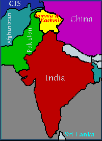
Azad and Jammu Kashmir Kashmir is an area on the northern borders of
India and Pakistan; officially known as Jammu & Kashmir. Kashmir is
famous for its natural beauty and has often been referred to as the
'Switzerland of the East'. The heart of the area is the fertile Vale of
Kashmir (known as The Valley), which lies between the Himalayas and the
Pir Panjal mountain range. Here the climate is mild and the soil well
watered. Kashmir covers an area of 222,237 SqKm (85,800 SqMi). Mount
Godwin Austen/K2 (8,611m/28,250 ft) and mount Nanga Parbat
(8,123m/26,650 ft) lie in Northern Kashmir.
 The
Indus river flows through Kashmir. The river Jhelum flows through the
Vale of Kashmir. The mountains have much precious forests. About 12
million people live in Kashmir, of which around 70% are Muslims. The
rest include Hindus, Sikhs and Buddhists. Hindus live mostly in the
south and around the city of Jammu. To the east is the Ladakh region,
where the majority of the people are Buddhists and of Tibetan origin.
Most of the Kashmiri people work on farms. Others are engaged in small
industries making shawls, rugs and carpets. Kashmir is well known for
its wool and, in particular, its shawls and carpets. Much of the
farmland is under intense cultivation, producing corn, wheat, rice and
saffron amongst other crops. Fruit and nuts are also produced in
quantities including pears, apples and walnuts.
The
Indus river flows through Kashmir. The river Jhelum flows through the
Vale of Kashmir. The mountains have much precious forests. About 12
million people live in Kashmir, of which around 70% are Muslims. The
rest include Hindus, Sikhs and Buddhists. Hindus live mostly in the
south and around the city of Jammu. To the east is the Ladakh region,
where the majority of the people are Buddhists and of Tibetan origin.
Most of the Kashmiri people work on farms. Others are engaged in small
industries making shawls, rugs and carpets. Kashmir is well known for
its wool and, in particular, its shawls and carpets. Much of the
farmland is under intense cultivation, producing corn, wheat, rice and
saffron amongst other crops. Fruit and nuts are also produced in
quantities including pears, apples and walnuts.
In 1757 it was conquered by Ahmed Shah Durrani and became part of Afghanistan. In 1819 Ranjit Singh conquered Kashmir and made it part of his Sikh empire. In 1846, when the British defeated the Sikhs and annexed Punjab, they sold Kashmir to Ghulab Singh of Jammu for Rs. 7.5 million under the Treaty of Amritsar. Ghulab Singh, who entitled himself the Mahrajah, signed a separate treaty with the British which, in effect, gave him the status of an independent princely ruler of Kashmir. He added to his dominion by conquering Ladakh. Ghulab Singh died in 1857 and was replaced by Rambir Singh (1857-1885). Two other Marajahs, Partab Singh (1885-1925) and Hari Singh (1925-1949) ruled in succession.
 Ghulab
Singh and his successors ruled Kashmir in a tyrannical and repressive
way. The people of Kashmir, nearly 80% of whom were Muslims, rose
against Mahraja Hari Singh's rule. He ruthlessly crushed a mass uprising
in 1931. In 1932 Sheik Abdullah formed Kashmir's first political party -
All Jammu & Kashmir Muslim Conference (renamed to National
Conference in 1939). In 1934 the Maharajah gave way and allowed limited
democracy in the form of a Legislative Assembly. However, unease with
the Maharaja's rule continued. According to the instruments of partition
of India in 1947, the rulers of princely states were given the choice
to freely accede to either India or Pakistan, or to remain independent.
They were, however, advised to accede to the contiguous dominion, taking
into consideration the geographical and ethnic issues. In Kashmir,
however, the Maharajah hesitated. The principally Muslim population
having seen the early and covert arrival of Indian troops, rebelled and
things got out of the Maharajah's hands. The people of Kashmir were
undoubtedly demanding to join Pakistan. The Maharajah, fearing tribal
warfare, eventually gave way to the Indian pressure and agreed to join
India by 'signing' the Instrument of Accession on 26th October 1947.
Kashmir was provisionally accepted into the Indian Union pending a free
and impartial plebiscite. This was spelled out in a letter from the
Governor General of India, Lord Mountbatten, to the Maharajah on 27th
October 1947. In the letter, accepting the Accession, Mountbatten made
it clear that the state would only be incorporated into the Indian Union
after a reference had been made to the people of Kashmir. Having
accepted the principle of a plebiscite, India has since obstructed all
attempts at arranging one. Heavy fighting took place in 1947-48 between
the Indian and Pakistani forces over Kashmir. On 1st January 1949 a
cease-fire was declared which created the first Line-of-Control.
Ghulab
Singh and his successors ruled Kashmir in a tyrannical and repressive
way. The people of Kashmir, nearly 80% of whom were Muslims, rose
against Mahraja Hari Singh's rule. He ruthlessly crushed a mass uprising
in 1931. In 1932 Sheik Abdullah formed Kashmir's first political party -
All Jammu & Kashmir Muslim Conference (renamed to National
Conference in 1939). In 1934 the Maharajah gave way and allowed limited
democracy in the form of a Legislative Assembly. However, unease with
the Maharaja's rule continued. According to the instruments of partition
of India in 1947, the rulers of princely states were given the choice
to freely accede to either India or Pakistan, or to remain independent.
They were, however, advised to accede to the contiguous dominion, taking
into consideration the geographical and ethnic issues. In Kashmir,
however, the Maharajah hesitated. The principally Muslim population
having seen the early and covert arrival of Indian troops, rebelled and
things got out of the Maharajah's hands. The people of Kashmir were
undoubtedly demanding to join Pakistan. The Maharajah, fearing tribal
warfare, eventually gave way to the Indian pressure and agreed to join
India by 'signing' the Instrument of Accession on 26th October 1947.
Kashmir was provisionally accepted into the Indian Union pending a free
and impartial plebiscite. This was spelled out in a letter from the
Governor General of India, Lord Mountbatten, to the Maharajah on 27th
October 1947. In the letter, accepting the Accession, Mountbatten made
it clear that the state would only be incorporated into the Indian Union
after a reference had been made to the people of Kashmir. Having
accepted the principle of a plebiscite, India has since obstructed all
attempts at arranging one. Heavy fighting took place in 1947-48 between
the Indian and Pakistani forces over Kashmir. On 1st January 1949 a
cease-fire was declared which created the first Line-of-Control.
 In 1957 the state was, in effect, incorporated into the Indian Union
under a new Constitution. This was done in direct contravention of the
standing UN resolutions and the conditions of the Instrument of
Accession. The article was rushed through by the then puppet state
government of Bakshi Ghulam Mohammed; people of Kashmir were not
consulted. Heavy fighting broke out again in 1965 between India and
Pakistan over Kashmir. A cease-fire was established in September 1965.
Indian Prime Minister, Lal Bhadur Shastri, and Pakistani President, M
Ayub Khan, signed the Tashkent agreement on 1st January 1966. They
resolved to try to end the dispute by peaceful means. In 1971 civil war
broke out in East Pakistan and Indian forces again fought the Pakistani
forces in Kashmir. This resulted in a new cease-fire and the signing of
the Shimla Agreement by Indira Ghandi and Z A Bhutto. The Shimla
Agreement basically reiterated the promises made in Tashkent.
In 1957 the state was, in effect, incorporated into the Indian Union
under a new Constitution. This was done in direct contravention of the
standing UN resolutions and the conditions of the Instrument of
Accession. The article was rushed through by the then puppet state
government of Bakshi Ghulam Mohammed; people of Kashmir were not
consulted. Heavy fighting broke out again in 1965 between India and
Pakistan over Kashmir. A cease-fire was established in September 1965.
Indian Prime Minister, Lal Bhadur Shastri, and Pakistani President, M
Ayub Khan, signed the Tashkent agreement on 1st January 1966. They
resolved to try to end the dispute by peaceful means. In 1971 civil war
broke out in East Pakistan and Indian forces again fought the Pakistani
forces in Kashmir. This resulted in a new cease-fire and the signing of
the Shimla Agreement by Indira Ghandi and Z A Bhutto. The Shimla
Agreement basically reiterated the promises made in Tashkent.
 Hindustan Times of August 1970 reports, "In the Kashmir People's
Convention held in Srinagar in the summer of 1970, but for a few feeble
voices in our [India's] favour, most of the delegates favoured either
accession to Pakistan or creation of an independent Kashmir". The close
of 1989 saw the beginning of the renewed struggle for freedom of
Kashmir. The Kashmiris started to arm themselves to resist the Indian
occupation. The then state government, headed by Dr Farooq Abdullah, was
dissolved and the state placed in direct control of the governor. Since
then the struggle for freedom and democracy has intensified.
Hindustan Times of August 1970 reports, "In the Kashmir People's
Convention held in Srinagar in the summer of 1970, but for a few feeble
voices in our [India's] favour, most of the delegates favoured either
accession to Pakistan or creation of an independent Kashmir". The close
of 1989 saw the beginning of the renewed struggle for freedom of
Kashmir. The Kashmiris started to arm themselves to resist the Indian
occupation. The then state government, headed by Dr Farooq Abdullah, was
dissolved and the state placed in direct control of the governor. Since
then the struggle for freedom and democracy has intensified.
The state of Azad Jammu and Kashmir lies between longitude 73o – 75o and latitude 33o – 36o and comprises an area of 5134 square miles (13,297 square kilometers). The topography of the area is mainly hilly and mountainous with valleys and stretches of plains. The area is full of natural beauty with thick forest, fast flowing rivers and winding streams. Main rivers are Jehlum, Neelum and Poonch. The climate is sub-tropical highland type with an average yearly rainfall of 1300 mm. The elevation ranges from 360 meters in the south to 6325 meters in the north
.
===========================================================
History and Life in Kashmir
 The
Indus river flows through Kashmir. The river Jhelum flows through the
Vale of Kashmir. The mountains have much precious forests. About 12
million people live in Kashmir, of which around 70% are Muslims. The
rest include Hindus, Sikhs and Buddhists. Hindus live mostly in the
south and around the city of Jammu. To the east is the Ladakh region,
where the majority of the people are Buddhists and of Tibetan origin.
Most of the Kashmiri people work on farms. Others are engaged in small
industries making shawls, rugs and carpets. Kashmir is well known for
its wool and, in particular, its shawls and carpets. Much of the
farmland is under intense cultivation, producing corn, wheat, rice and
saffron amongst other crops. Fruit and nuts are also produced in
quantities including pears, apples and walnuts.
The
Indus river flows through Kashmir. The river Jhelum flows through the
Vale of Kashmir. The mountains have much precious forests. About 12
million people live in Kashmir, of which around 70% are Muslims. The
rest include Hindus, Sikhs and Buddhists. Hindus live mostly in the
south and around the city of Jammu. To the east is the Ladakh region,
where the majority of the people are Buddhists and of Tibetan origin.
Most of the Kashmiri people work on farms. Others are engaged in small
industries making shawls, rugs and carpets. Kashmir is well known for
its wool and, in particular, its shawls and carpets. Much of the
farmland is under intense cultivation, producing corn, wheat, rice and
saffron amongst other crops. Fruit and nuts are also produced in
quantities including pears, apples and walnuts.
Kashmir has
been the key to the dispute between India and Pakistan since their
independence from the British in 1947. Each country claims Kashmir as a
part of its territory. As a result of a rebellion in 1947 and the
subsequent wars between India and Pakistan over Kashmir, the area is
separated by a Line-of-Control (LOC or cease-fire line). To the east of
the LOC lies the vale of Kashmir, Jammu and Ladakh which are
administered by India. To the west lies the area now known as 'Azad
[Free] Kashmir' which is governed by its own government with strong ties
with Pakistan.
The capitals of Indian-held Kashmir are Srinagar in the summer and Jammu in the winter; whilst the capital of Azad Kashmir is
Muzaffarabad. Since 1989 the controversy over Kashmir has taken a
violent turn in the valley; the Kashmiri people themselves have taken up
arms against the Indian occupation. India is now deploying more than
700,000 troops in the valley to crush the Freedom Movement.
Background of Kashmir
Background of Kashmir
Tradition
has it that Kashmir was originally a lake that was drained by Kashyap
and then inhabited by the Brahmins. Buddhism was introduced by the
missionaries of Ashoka and flourished under the rule of Kushan in 2nd
Century AD. However, Hinduism continued to be the dominant religion. In
the 7th Century AD, the Karkota dynasty was founded by
Durlabhavarrdhana. In 855 AD the Utpalas replaced the Karkotas. Later,
the Tantrins, Yaskaras and Parva Gupta ruled in succession. Didda, a
Gupta widowed queen, ruled Kashmir until 1003 AD when the Lohara dynasty
took over. In 1346 AD the last Hindu king, Udiana Deva, was replaced by
Shams-ud-Din. His family ruled until 1586 when the Moghul emperor Akbar
conquered and annexed Kashmir to his vast empire.
In 1757 it was conquered by Ahmed Shah Durrani and became part of Afghanistan. In 1819 Ranjit Singh conquered Kashmir and made it part of his Sikh empire. In 1846, when the British defeated the Sikhs and annexed Punjab, they sold Kashmir to Ghulab Singh of Jammu for Rs. 7.5 million under the Treaty of Amritsar. Ghulab Singh, who entitled himself the Mahrajah, signed a separate treaty with the British which, in effect, gave him the status of an independent princely ruler of Kashmir. He added to his dominion by conquering Ladakh. Ghulab Singh died in 1857 and was replaced by Rambir Singh (1857-1885). Two other Marajahs, Partab Singh (1885-1925) and Hari Singh (1925-1949) ruled in succession.
 Ghulab
Singh and his successors ruled Kashmir in a tyrannical and repressive
way. The people of Kashmir, nearly 80% of whom were Muslims, rose
against Mahraja Hari Singh's rule. He ruthlessly crushed a mass uprising
in 1931. In 1932 Sheik Abdullah formed Kashmir's first political party -
All Jammu & Kashmir Muslim Conference (renamed to National
Conference in 1939). In 1934 the Maharajah gave way and allowed limited
democracy in the form of a Legislative Assembly. However, unease with
the Maharaja's rule continued. According to the instruments of partition
of India in 1947, the rulers of princely states were given the choice
to freely accede to either India or Pakistan, or to remain independent.
They were, however, advised to accede to the contiguous dominion, taking
into consideration the geographical and ethnic issues. In Kashmir,
however, the Maharajah hesitated. The principally Muslim population
having seen the early and covert arrival of Indian troops, rebelled and
things got out of the Maharajah's hands. The people of Kashmir were
undoubtedly demanding to join Pakistan. The Maharajah, fearing tribal
warfare, eventually gave way to the Indian pressure and agreed to join
India by 'signing' the Instrument of Accession on 26th October 1947.
Kashmir was provisionally accepted into the Indian Union pending a free
and impartial plebiscite. This was spelled out in a letter from the
Governor General of India, Lord Mountbatten, to the Maharajah on 27th
October 1947. In the letter, accepting the Accession, Mountbatten made
it clear that the state would only be incorporated into the Indian Union
after a reference had been made to the people of Kashmir. Having
accepted the principle of a plebiscite, India has since obstructed all
attempts at arranging one. Heavy fighting took place in 1947-48 between
the Indian and Pakistani forces over Kashmir. On 1st January 1949 a
cease-fire was declared which created the first Line-of-Control.
Ghulab
Singh and his successors ruled Kashmir in a tyrannical and repressive
way. The people of Kashmir, nearly 80% of whom were Muslims, rose
against Mahraja Hari Singh's rule. He ruthlessly crushed a mass uprising
in 1931. In 1932 Sheik Abdullah formed Kashmir's first political party -
All Jammu & Kashmir Muslim Conference (renamed to National
Conference in 1939). In 1934 the Maharajah gave way and allowed limited
democracy in the form of a Legislative Assembly. However, unease with
the Maharaja's rule continued. According to the instruments of partition
of India in 1947, the rulers of princely states were given the choice
to freely accede to either India or Pakistan, or to remain independent.
They were, however, advised to accede to the contiguous dominion, taking
into consideration the geographical and ethnic issues. In Kashmir,
however, the Maharajah hesitated. The principally Muslim population
having seen the early and covert arrival of Indian troops, rebelled and
things got out of the Maharajah's hands. The people of Kashmir were
undoubtedly demanding to join Pakistan. The Maharajah, fearing tribal
warfare, eventually gave way to the Indian pressure and agreed to join
India by 'signing' the Instrument of Accession on 26th October 1947.
Kashmir was provisionally accepted into the Indian Union pending a free
and impartial plebiscite. This was spelled out in a letter from the
Governor General of India, Lord Mountbatten, to the Maharajah on 27th
October 1947. In the letter, accepting the Accession, Mountbatten made
it clear that the state would only be incorporated into the Indian Union
after a reference had been made to the people of Kashmir. Having
accepted the principle of a plebiscite, India has since obstructed all
attempts at arranging one. Heavy fighting took place in 1947-48 between
the Indian and Pakistani forces over Kashmir. On 1st January 1949 a
cease-fire was declared which created the first Line-of-Control. In 1957 the state was, in effect, incorporated into the Indian Union
under a new Constitution. This was done in direct contravention of the
standing UN resolutions and the conditions of the Instrument of
Accession. The article was rushed through by the then puppet state
government of Bakshi Ghulam Mohammed; people of Kashmir were not
consulted. Heavy fighting broke out again in 1965 between India and
Pakistan over Kashmir. A cease-fire was established in September 1965.
Indian Prime Minister, Lal Bhadur Shastri, and Pakistani President, M
Ayub Khan, signed the Tashkent agreement on 1st January 1966. They
resolved to try to end the dispute by peaceful means. In 1971 civil war
broke out in East Pakistan and Indian forces again fought the Pakistani
forces in Kashmir. This resulted in a new cease-fire and the signing of
the Shimla Agreement by Indira Ghandi and Z A Bhutto. The Shimla
Agreement basically reiterated the promises made in Tashkent.
In 1957 the state was, in effect, incorporated into the Indian Union
under a new Constitution. This was done in direct contravention of the
standing UN resolutions and the conditions of the Instrument of
Accession. The article was rushed through by the then puppet state
government of Bakshi Ghulam Mohammed; people of Kashmir were not
consulted. Heavy fighting broke out again in 1965 between India and
Pakistan over Kashmir. A cease-fire was established in September 1965.
Indian Prime Minister, Lal Bhadur Shastri, and Pakistani President, M
Ayub Khan, signed the Tashkent agreement on 1st January 1966. They
resolved to try to end the dispute by peaceful means. In 1971 civil war
broke out in East Pakistan and Indian forces again fought the Pakistani
forces in Kashmir. This resulted in a new cease-fire and the signing of
the Shimla Agreement by Indira Ghandi and Z A Bhutto. The Shimla
Agreement basically reiterated the promises made in Tashkent.
Since
the 1971 war, the situation may have been described as stalemate with
India in control of much the larger part of Kashmir, and doing
everything to emphasis her claim de jur. However, the dream of freedom
from India never died; it was only suppressed from time to time by the
Indians by using puppet state governments. Guardian on 14th July 1970
reports that it is "ironic that India's position in Kashmir should be
increasingly challenged from within at a time when Kashmir's status as a
major unsettled international dispute is declining".
 Hindustan Times of August 1970 reports, "In the Kashmir People's
Convention held in Srinagar in the summer of 1970, but for a few feeble
voices in our [India's] favour, most of the delegates favoured either
accession to Pakistan or creation of an independent Kashmir". The close
of 1989 saw the beginning of the renewed struggle for freedom of
Kashmir. The Kashmiris started to arm themselves to resist the Indian
occupation. The then state government, headed by Dr Farooq Abdullah, was
dissolved and the state placed in direct control of the governor. Since
then the struggle for freedom and democracy has intensified.
Hindustan Times of August 1970 reports, "In the Kashmir People's
Convention held in Srinagar in the summer of 1970, but for a few feeble
voices in our [India's] favour, most of the delegates favoured either
accession to Pakistan or creation of an independent Kashmir". The close
of 1989 saw the beginning of the renewed struggle for freedom of
Kashmir. The Kashmiris started to arm themselves to resist the Indian
occupation. The then state government, headed by Dr Farooq Abdullah, was
dissolved and the state placed in direct control of the governor. Since
then the struggle for freedom and democracy has intensified. The state of Azad Jammu and Kashmir lies between longitude 73o – 75o and latitude 33o – 36o and comprises an area of 5134 square miles (13,297 square kilometers). The topography of the area is mainly hilly and mountainous with valleys and stretches of plains. The area is full of natural beauty with thick forest, fast flowing rivers and winding streams. Main rivers are Jehlum, Neelum and Poonch. The climate is sub-tropical highland type with an average yearly rainfall of 1300 mm. The elevation ranges from 360 meters in the south to 6325 meters in the north


.jpg)


